 Share Your Feedback on Rudee Park Concept Features
Share Your Feedback on Rudee Park Concept Features
Let's write the Rudee Park story, together.
Following decades of debate and public input, the City of Virginia Beach has committed to open public access and use of the Rudee Loop site by creating a world-class public destination, Rudee Park.
At the end of 2024, the Rudee Park design team hosted three community events and an online survey to gather feedback on the programs and amenities residents want to see in the park. The team also engaged high school students across Virginia Beach to incorporate a younger perspective into the vision. So far, Phase 1 has collected over 48,000 data points from these sources:
Verbal and written comments from in-person events
Student discussions
Community events
Stakeholder focus groups
Online survey
In total, nearly 7,000 people across the City contributed their voices. The community's input has been instrumental in shaping the three design concepts presented in this survey. They explore different amenities and programs that could be included in the future Rudee Park.
Thank you in advance for taking the time to complete this survey! Your time is valuable, and your feedback is greatly appreciated.
Each concept has three sets of questions, and each set relates to a specific area of the concept design. Please review each numbered area, answer each question and tell us why you chose that answer in the comment section.
Concept 1:
(Click the graphic to open a larger view)
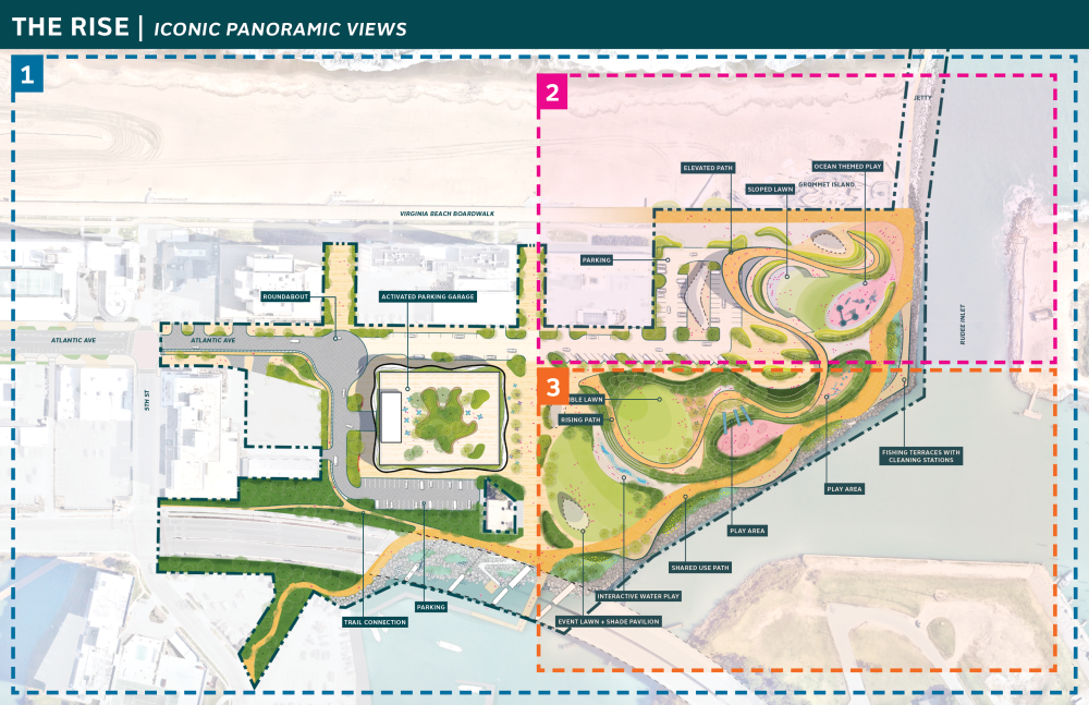
Image Caption: The concept above shows a possible design for Rudee Park entitled The Rise. Important design elements that the map includes are:
- Atlantic Avenue: how it enters the park and a possible roundabout
- Parking garage: between the bridge and Atlantic, with plantings on top
- Surface parking: along Atlantic, near the boardwalk, and behind the garage
- Shared use path for pedestrians and cyclists: wide orange ribbon connecting from below the bridge, along the water, to the boardwalk
- Play areas
- Interactive water play
- Lawns and greenspace
- An elevated walkway: thinner orange path that begins to the right of the garage, slopes up while winding through the park, and descends to connect to the boardwalk
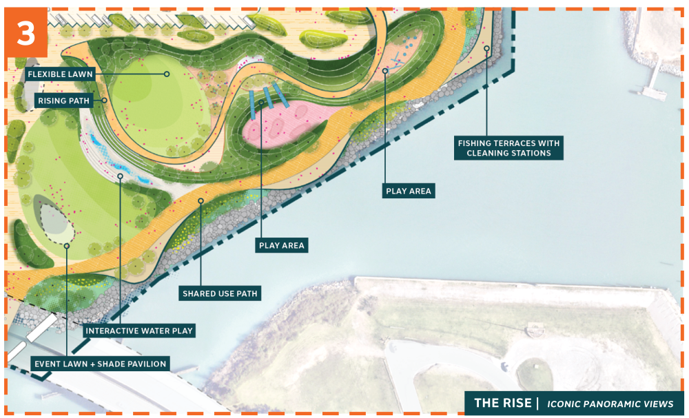
The map includes three sections labeled 1) the overall plan, 2) the section of the park which touches the boardwalk, facing the beach, and 3) the section of the park along the inlet edge, facing the bridge.
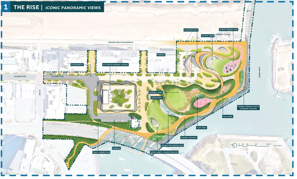
Concept 1: Area 1 Questions
Please review the graphic below and answer the questions.
The image below shows the full zoomed out concept of “The Rise.” (Click the graphic to open a larger view)
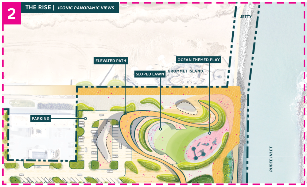
Concept 1: Area 2 Questions
Please review the graphic below and answer the questions.
The image below shows a zoomed in area of the park near the Boardwalk on the ocean-facing side of the park. (Click the graphic to open a larger view)
Concept 1: Area 3 Questions
Please review the graphic below and answer the questions.
The image below shows a zoomed in area of the inlet side of the park. (Click the graphic to open a larger view)